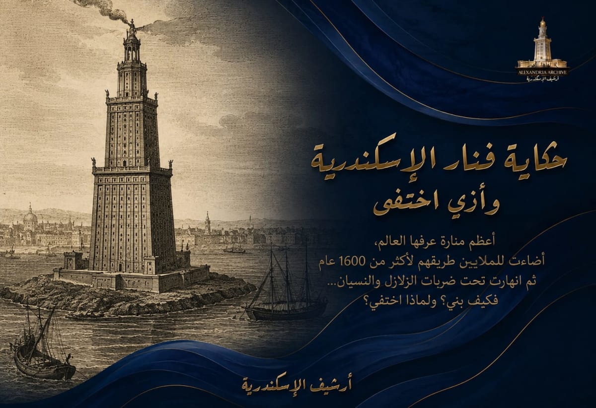
دراسة تاريخية وأثرية وجيولوجية شاملة لمنار الإسكندرية القديم (النشأة، العمارة، وأسباب الاندثار)
أرشيف الإسكندرية —
مقدمة جيو-تاريخية: حتمية التأسيس في مواجهة الطبيعة
لطالما شكلت مدينة الإسكندرية نقطة التقاء محورية بين حضارات الشرق والغرب منذ تأسيسها على يد الإسكندر الأكبر عام 332 قبل الميلاد. تستند السرديات الكلاسيكية، وتحديداً ما نقله المؤرخ الروماني بلوتارخ، إلى أن الإسكندر الأكبر رأى في منامه الشاعر الإغريقي هوميروس ينشد أبياتاً من ملحمته "الأوديسة"، يصف فيها جزيرة تُدعى "فاروس" تقع في وسط الأمواج العاتية قبالة السواحل المصرية وتتميز بمرفأ آمن، حيث أشار هوميروس إلى أن الجزيرة كانت موطناً للإله بروتيوس، "شيخ البحر" الأسطوري. بناءً على هذه الرؤية الملحمية، توجه الإسكندر إلى الموقع وأدرك العبقرية الجغرافية للمكان، المتمثل في نتوء من الحجر الجيري يبرز وسط السواحل الرملية المنخفضة، فقرر بناء مدينته العظيمة قبالة تلك الجزيرة، وربطها لاحقاً باليابسة عبر جسر "الهيبتاستاديون" (Heptastadion) الذي بلغ طوله حوالي 1200 متر أو سبعة ملاعب إغريقية.
إلا أن الجغرافيا الطبيعية للسواحل الشمالية لمصر كانت تفرض تحديات ملاحية قاسية؛ فقد أوضح المؤرخ ديودور الصقلي أن الشواطئ الممتدة من "بارايتونيوم" في ليبيا إلى "يوبي" في سوريا كانت مسطحة، وتفتقر إلى العلامات التضاريسية البارزة كالجبال أو المنحدرات التي يمكن للبحارة الاستدلال بها2. وبالإضافة إلى ذلك، وجد حزام من المياه الضحلة والشعاب المرجانية المزدوجة والمغمورة التي شكلت فخاخاً مميتة للسفن التجارية والعسكرية على حد سواء، مما جعل الملاحة نحو الإسكندرية خطراً داهماً للملاحين غير الملمين بتضاريسها1. ومع تعاظم دور الإسكندرية كعاصمة اقتصادية وثقافية للعالم الهلنستي، برزت حاجة جيو-إستراتيجية ملحة لإنشاء علامة ملاحية عملاقة ترشد السفن لتجنب تلك الشعاب، وهو ما شكل الدافع الأساسي لبناء ما سيُعرف لاحقاً بأول وأعظم منارة في تاريخ البشرية، والتي لم تقتصر وظيفتها على الإرشاد الملاحي فحسب، بل امتدت لتصبح رمزاً لهيمنة وثروة الإمبراطورية البطلمية.
التأسيس البطلمي والعبقرية الهندسية لسوستراتوس
بعد وفاة الإسكندر الأكبر وتأسيس المملكة البطلمية، انطلقت ورشة بناء وتأسيس مدينة الإسكندرية لتكون درة التاج في شرق البحر الأبيض المتوسط1. وفي هذا السياق، كُلّف المهندس والدبلوماسي الإغريقي العبقري "سوستراتوس الكنيدي" (Sostratus of Cnidus)، نجل دكسيفانيس، بتصميم والإشراف على بناء منارة ضخمة على الطرف الشرقي لجزيرة فاروس. تشير الأبحاث الحديثة والمصادر الكلاسيكية إلى أن سوستراتوس لم يكن مجرد مهندس معماري تقليدي، بل كان مبعوثاً دبلوماسياً رفيع المستوى في بلاط بطليموس الأول، ومهندساً يمتلك خبرات سابقة في ترويض الطبيعة، حيث ساهم في هندسة سدود على نهر النيل لتسهيل استيلاء بطليموس على مصر، فضلاً عن بناء ممرات معلقة بديعة في مسقط رأسه مدينة كنيدوس.
بدأ العمل في المشروع الطموح في أواخر القرن الثالث قبل الميلاد (قرابة 299 أو 297 ق.م وفقاً لموسوعة سودا البيزنطية)، واستغرق البناء ما بين 12 إلى 20 عاماً، ليكتمل في عهد بطليموس الثاني (فيلادلفيوس) حوالي عام 280-279 قبل الميلاد1. بلغت التكلفة الإجمالية لهذا الصرح المعماري الاستثنائي حوالي 800 تالنت من الفضة (ما يعادل أكثر من 23 طناً من الفضة الخالصة)، وهو مبلغ فلكي بمعايير العالم القديم يعكس بوضوح الفائض الاقتصادي الهائل الذي كانت تتمتع به الخزانة البطلمية.
من القصص التاريخية ذات الدلالات العميقة التي ارتبطت ببناء الفنار، ما نقله الكاتب الإغريقي لوسيان (القرن الثاني الميلادي) وبلينيوس الأكبر، حول كيفية تخليد المهندس سوستراتوس لاسمه. فقد قام سوستراتوس بنحت اسمه وإهدائه على الحجر الصلب بعبارة: "سوستراتوس بن دكسيفانيس الكنيدي، إلى الآلهة المنقذة، من أجل بحارة السفن"، ثم قام بتغطية هذا النقش بطبقة من الجص (Gypsum) القابل للذوبان وكتب عليها اسم الملك بطليموس1. كان سوستراتوس يعلم يقيناً أن عوامل التعرية ورذاذ البحر المالح ستذيب الجص مع مرور الزمن ليكشف عن اسمه المعدني الأبدي، وهو ما يشير إلى نزعة الفردية والاعتزاز بالعبقرية الهندسية التي ميزت العصر الهلنستي، على الرغم من أن المؤرخ بلينيوس يرى أن الملك بطليموس كان كريماً بما يكفي للسماح للمهندس بنقش اسمه بحرية.
التصميم المعماري والتقنيات الهندسية الفائقة
أجمع المؤرخون والرحالة القدامى على أن منار الإسكندرية كان عملاً هندسياً يفوق الوصف، حيث تخطى ارتفاعه 100 متر (وتشير الدراسات التحليلية الحديثة والمقارنات المستندة لوصف الرحالة إلى أن ارتفاعه تراوح بين 103 و 118 متراً، وربما وصل إلى 130 متراً أو أكثر من 350 قدماً)، مما جعله أعلى مبنى من صنع الإنسان في العالم القديم بعد أهرامات الجيزة، بل ويُعد النموذج المعماري الأول لجميع المنارات التي شُيدت لاحقاً (Archetype)، وربما ناطحة السحاب الأولى في تاريخ البشرية.
استُخدمت في بناء الفنار تقنيات متطورة للغاية لمقاومة الزلازل وأمواج البحر العاتية. أظهرت الاكتشافات الأثرية الحديثة تحت الماء استخدام البنائين لكتل ضخمة من الحجر الجيري الأبيض والجرانيت الصلب المجلوب من أسوان ومحاجر المكس، مع استخدام عناصر ربط معدنية متطورة من الرصاص والحديد والبرونز لدمج الكتل الحجرية ببعضها البعض (Clamps and Dowels)، مما منح الهيكل مرونة وديمومة سمحت له بالصمود لقرابة 16 قرناً أمام الكوارث الطبيعية المتكررة.
الهيكل الثلاثي والتقسيم الداخلي للفنار
تميز التصميم المعماري للفنار بالتدرج الانسيابي نحو الأعلى، متألفاً من ثلاثة أقسام رئيسية متناقصة الحجم، والتي اعتمدت في توصيفها على القياسات الدقيقة التي أوردها الرحالة الأندلسي "أبو الحجاج يوسف بن محمد البلوي" الذي زار الإسكندرية عام 1166م وقاس الأبعاد الداخلية بنفسه:
<table><tbody><tr><td><strong>القسم / الطابق</strong></td><td><strong>الوصف والشكل الهندسي</strong></td><td><strong>الخصائص والوظيفة</strong></td></tr><tr><td><strong>القسم الأول (القاعدة)</strong></td><td>قاعدة مربعة ضخمة (حوالي 30x30 متراً).</td><td>بلغ ارتفاعه نحو 56-70 متراً. احتوى على حوالي 300 غرفة موزعة على عدة طوابق لإيواء الفنيين وعائلاتهم، ومستودعات للوقود والأسلحة. داخله منحدر حلزوني واسع سقفه مبني بالطوب (بارتفاع 189 سم) يكفي لمرور دابتين محملتين بالوقود للمرور في آن واحد. وتوزعت غرفه بواقع 18، 14، و17 غرفة في الطوابق الثاني والثالث والرابع على التوالي1.</td></tr><tr><td><strong>القسم الثاني (الأوسط)</strong></td><td>طابق مُثمّن الأضلاع (Octagonal).</td><td>تراوح ارتفاعه بين 28 إلى 35 متراً. استُخدم كنقطة مراقبة، وزُينت أركانه بتماثيل ضخمة لآلهة البحر "ترايتون" (Triton) التي كانت تعمل كأدوات زينة، وربما شملت آليات للتحذير الصوتي6.</td></tr><tr><td><strong>القسم الثالث (القمة)</strong></td><td>طابق أسطواني دائري (Cylindrical).</td><td>تراوح ارتفاعه بين 28 إلى 30 متراً. احتوى على نظام الإضاءة المعقد (المرآة والمجمرة)، وكان يعلوه تمثال برونزي ضخم للإله زيوس (Zeus) أو بوسيدون (Poseidon)، أو ربما للملك بطليموس الثاني في هيئة إله الشمس هليوس4.</td></tr></tbody></table>
ديناميكا الإضاءة ونظام الإنذار المبكر
تؤكد الدراسات المعمارية أن المنار في مراحله الأولى ربما لم يكن مضاءً بالنار، بل اعتمد كنقطة علام نهارية شاهقة الارتفاع ومطلية باللون الأبيض العاكس لأشعة الشمس، قبل أن يُحول في القرن الأول قبل الميلاد (كما أشار بلينيوس الأكبر) إلى منارة ليلية فعلية. وقد ارتكز نظام الإضاءة الليلي والنهاري على تقنيتين أساسيتين شكلتا قمة التطور الميكانيكي في العصر الهلنستي:
المرآة العاكسة (The Reflector): مرآة ضخمة من البرونز المصقول (أو الحديد الصيني كما أشارت بعض المصادر العربية كأبي حامد الغرناطي، بقطر بلغ حوالي 7 أذرع أو 364 سم)، وُضعت في قمة الفنار لتوجيه وعكس ضوء الشمس نهاراً، وضوء النار ليلاً6. ادعت بعض الأساطير المتطرفة أن هذه المرآة كانت تستخدم كعدسة حارقة لتدمير سفن الأعداء، أو لمراقبة الأساطيل القادمة من اليونان والقسطنطينية وهي لا تزال في عرض البحر.
المجمرة العظمى وديناميكا الوقود: فرن عملاق يتم إشعاله ليلاً ليُرى نوره من مسافة تتراوح بين 40 إلى 100 كيلومتر (حوالي 300 غلوة بحرية، أو 300 ستاديا كما أشار يوسيفوس)2. يثير هذا النظام تحديات ديناميكية حرارية حادة؛ فقد حسب عالم الآثار الألماني هيرمان ثيرش (Hermann Thiersch) في دراسته الكلاسيكية عام 1909، أن ناراً قادرة على الوصول إلى هذا المدى وتوليد 10 ميجاوات من الطاقة تتطلب حوالي 50 طناً من الأخشاب يومياً، وهو ما يعادل استهلاك غابة كاملة سنوياً. ونظراً لافتقار مصر القديمة لموارد خشبية بهذا الحجم، واستحالة تحمل الحجارة المحيطة لهذه الحرارة الهائلة دون أن تتفتت، يرجح الخبراء استخدام آليات عاكسة متطورة جداً لتركيز شعاع ضوئي أصغر حجماً، أو استخدام وقود سائل كالنفط والزيوت المشتعلة بدلاً من الحطب الصرف.
الآليات الصوتية (Acoustic Warnings): أشارت الروايات العربية وبعض النقود الرومانية إلى صدور "أصوات رهيبة" من المبنى لتحذير السفن أثناء الضباب. ويرجح أن تماثيل "ترايتون" الموجودة على حواف الطابق المثمن كانت متصلة بآليات تعمل بالبخار لتنفخ في أبواق حلزونية مخروطية، وهو تطبيق عملي لمعارف المهندس السكندري "هيرو" (Hero of Alexandria) الذي صمم آلات بخارية لإصدار أصوات تحذيرية.
الفنار في عيون التاريخ: من السجلات الكلاسيكية إلى الرحالة العرب
ترك منار الإسكندرية أثراً سيكولوجياً ومعمارياً هائلاً على كل من شاهده، وانعكس ذلك بوضوح في تراث أدبي وجغرافي ممتد.
الشهادات الكلاسيكية والإمبراطورية
أبدى القادة والمؤرخون الرومان إعجاباً فائقاً بالمنار. فقد وصفه يوليوس قيصر في مذكراته بأنه "برج عظيم الارتفاع، وعمل ذو بناء رائع أخذ اسمه من الجزيرة"، وقد أدرك قيصر أهميته الإستراتيجية العسكرية فاستولى عليه لضمان خطوط الإمداد لقواته إبان حربه مع جيوش بطليموس الثالث عشر عام 48 قبل الميلاد1. وفي روما، أمر قيصر بعرض مجسم مصغر للمنار تعلوه شعلة في موكبه الانتصاري تعبيراً عن هيمنة روما على أعظم عجائب الدنيا2. بدوره، أشار المؤرخ يوسيفوس إلى أن ضوء المنار كان يُرى من مسافة تعادل مسيرة يوم كامل في البحر، بينما حذر بلينيوس الأكبر من الخطر المتمثل في إمكانية الخلط بين ضوء المنار شديد السطوع وضوء النجوم الحقيقية في السماء المظلمة. وقد أسهب الجغرافي سترابو في وصف بنائه من الرخام الأبيض متعدد الطوابق، في حين شبهه الكاتب أخيل تاتيوس (القرن الثاني الميلادي) بالجبل الذي يعانق السحاب، وانسابت المياه من تحته.
التوثيق في العصور الإسلامية
بعد الفتح الإسلامي لمصر، استمر الفنار في أداء دوره الملاحي وحظي بعناية فائقة من المؤرخين والرحالة العرب الذين قدموا أدق التفاصيل المعمارية وأبعاد المبنى التي يُعتمد عليها اليوم في إعادة البناء الافتراضي. ومن أبرز هذه التوثيقات، ما نقله الجغرافي الشريف الإدريسي الذي زار المنار عام 1154م، مسجلاً استخدام الرصاص لملء الفراغات بين الكتل الحجرية في القاعدة، ومقدراً ارتفاعه بـ 300 ذراع رشاشي (حوالي 162 متراً)1. كما قدم الرحالة الأندلسي "أبو الحجاج يوسف بن محمد البلوي" الوصف الأكمل للتقسيمات الداخلية والمنحدر الصاعد كما أُسلف.
ويُبرز الرحالة الكبير ابن جبير (القرن الثاني عشر الميلادي) الأثر الروحي للمنار إبان زيارته، مشيراً إلى أن العيون تعجز عن إدراكه، وأن الله سخر من بناه ليكون "آية للمتوسمين وهداية للمسافرين"، وذكر وجود مسجد مبارك في أعلاه يتبرك الناس بالصلاة فيه10. أما المسعودي (القرن العاشر الميلادي) فقد قدم وصفاً دقيقاً للمنار، متطرقاً للكتابات اليونانية المنقوشة عليه والتي أشار إلى أنها مكرسة للإله زيوس.
الأساطير والخرافات: مؤامرة تدمير المرآة
نظراً لهيبة الفنار وما أثاره من تعجب، نُسجت حوله سلسلة من الأساطير الشعبية التي حاولت تفسير بداية خرابه بعيداً عن الكوارث الطبيعية البحتة. من أشهر هذه السرديات ما أورده المؤرخ المسعودي وغيره من الإخباريين، حول مؤامرة بيزنطية خبيثة استهدفت الفنار في عهد الخليفة الأموي عبد الملك بن مروان، أو ابنه الوليد بن عبد الملك.
تقول الرواية الخرافية إن إمبراطور الروم أرسل أحد خصيانه المقربين، فتظاهر باعتناق الإسلام والهروب من سيده، واستطاع التقرب من الخليفة الوليد بن عبد الملك بعد أن كشف له عن بعض الدفائن القديمة في الشام. وعندما وثق به الخليفة، أخبره الخصي أن هناك كنوزاً هائلة لملوك مصر العظماء (أو الإسكندر الأكبر، وشداد بن عاد) مخبأة في أقبية أسفل أساسات منار الإسكندرية. طمعاً في الكنز، أمر الخليفة بتفكيك الفنار والبحث تحته. وبمجرد أن نقض العمال نصف المنارة وأزالوا المرآة العاكسة العظيمة، ضج أهل الإسكندرية بالشكوى. وفي تلك الأثناء، وبعد أن أدرك الجاسوس البيزنطي أنه نجح في إبطال عمل المرآة التي كانت تكشف تحركات أساطيل الروم، هرب بحراً تحت جنح الظلام.
ورغم أن هذه القصة تفتقر إلى السند التاريخي والأثري الذي يؤكد دور الزلازل المتعاقبة في التدمير، إلا أنها تعكس فهماً سيكولوجياً واستراتيجياً عميقاً للأهمية التي كان يمثلها الفنار بالنسبة للإمبراطوريات المتعاقبة؛ فالمرآة كانت تعتبر نظام إنذار مبكر يكشف أساطيل العدو، وتدميرها كان يمثل اختراقاً أمنياً وانتصاراً عسكرياً للمنافسين البيزنطيين في حوض المتوسط.
التسلسل الزمني للاندثار: كيف ولماذا اختفى الفنار؟
على عكس العديد من المعالم الأثرية التي دمرتها الحروب أو جيوش الغزاة، كان اندثار منار الإسكندرية التام نتيجة حتمية للتفاعلات الجيولوجية العنيفة في شرق البحر الأبيض المتوسط. لقد واجه الفنار عبر 16 قرناً سلسلة من التحديات الطبيعية تمثلت في التآكل الملحي المستمر، العواصف العاتية، والهبوط التدريجي المستمر لقشرة الأرض الساحلية (Coastal Subsidence)، إلا أن الضربات القاضية جاءت من نشاط الزلازل وتسونامي، حيث تحمل الفنار قرابة 18 زلزالاً وموجة تسونامي عبر تاريخه الطويل.
يمكن تقسيم مراحل الانهيار والاندثار إلى سلسلة من الهزات الزلزالية العنيفة الموثقة تاريخياً:
<table><tbody><tr><td><strong>تاريخ الحدث</strong></td><td><strong>طبيعة الكارثة</strong></td><td><strong>الأضرار التي لحقت بالفنار وتأثيراتها</strong></td></tr><tr><td><strong>796 م</strong></td><td>زلزال إقليمي</td><td>تعرض الفنار لتصدعات كبيرة أضرت بالأساسات وتسببت في شروخ خطيرة في الطابق السفلي المربع9.</td></tr><tr><td><strong>956 م</strong></td><td>زلزال عنيف</td><td>أدى إلى انهيار القمة الدائرية وسقوط التمثال العملاق الذي يعلوها. استجابة لذلك، جرت محاولات لترميم المبنى حيث أضيفت قبة صغيرة (مسجد) على قمته المتبقية، واستمر في أداء جزء من وظيفته كبرج مراقبة9.</td></tr><tr><td><strong>8 أغسطس 1303 م</strong></td><td>زلزال جزيرة كريت العظيم وتسونامي مصاحب (الضربة القاصمة)</td><td>زلزال مدمر بقوة 8.0 درجات مركزه "القوس الهيليني"، نتجت عنه موجات تسونامي بارتفاع 9 أمتار ضربت الإسكندرية. تسبب في انقسام المنار إلى نصفين، وانهيار الأجزاء العلوية وتدمير معظم أسوار المدينة.</td></tr><tr><td><strong>1323 - 1326 م</strong></td><td>زلزال لاحق وتدهور نهائي</td><td>أطاحت هذه الهزات بما تبقى من الهيكل الهش للمبنى، ليتحول من ناطحة سحاب شامخة إلى كومة من الأنقاض المتراكمة غير القابلة للاستخدام16.</td></tr></tbody></table>
ديناميكية زلزال 1303 العظيم
يمثل القوس الهيليني (Hellenic Arc) في جنوب بحر إيجة منطقة اندساس تكتوني نشطة جداً، حيث تنزلق الصفيحة الأفريقية أسفل الصفيحة الأوراسية. في فجر يوم 8 أغسطس 1303م، تحررت طاقة هائلة بقوة قُدرت بنحو 8 درجات على مقياس ريختر (أقصى درجات مقياس ميركالي المعدل)27. لم تقتصر الكارثة على الهزة الأرضية، بل قذف الزلزال جداراً من المياه (تسونامي) عبر البحر الأبيض المتوسط، وصل إلى سواحل الإسكندرية في غضون 40 دقيقة فقط26.
وصف المؤرخون، كبيبرس المنصوري والمقريزي والعيني، هذا اليوم بيوم القيامة المصغر؛ حيث ذكر بيبرس المنصوري في كتابه "زبدة الفكرة": "كانت الزلزلة عظيمة حتى أن الجزر تساقطت والمباني تهدمت والصخور تقطعت والمياه من خلال الأرض"، بينما وصف العيني المشهد قائلاً: "الزلزال لو كان دام أكثر من ذلك لما كان بقي على الأرض دار أو ثبت بها جدار"16. تسبب الجدار المائي في قذف السفن إلى مسافة ميلين داخل اليابسة، وتشققت صهاريج المياه، وانقسم الفنار إلى نصفين وتداعت أجزاؤه العلوية26. ورغم محاولات السلطان الناصر محمد بن قلاوون، والأمير ركن الدين بيبرس الجاشنكير لترميم المنار عام 703 هـ، إلا أن الضرر الهيكلي كان أعمق من أن يُعالج16.
شهادة ابن بطوطة: رثاء الانهيار
تظهر سرعة التدهور في العقود الأخيرة من حياة الفنار من خلال شهادات الرحالة المغربي ابن بطوطة. فعندما زار الإسكندرية لأول مرة عام 1326م (بعد سلسلة الزلازل)، سجل أن المنار "أحد جوانبه في حالة خراب" ولكنه استطاع الدخول إليه ولاحظ وجود أماكن لجلوس حراس المنارة1. وعندما عاد بعد ثلاثة وعشرين عاماً فقط، في رحلته الثانية عام 1349م، وجد أن المنار قد انهار تماماً، حيث كتب بحسرة: "وقصدتُ المنارة، عند عودتي إلى بلاد المغرب، فوجدتها قد استولى عليها الخراب، بحيث لا يمكن دخولها ولا الصعود إلى بابها"1. هذا الفارق الزمني القصير يعكس تسارع وتيرة الانهيار التام للهيكل المتبقي.
التحول من منار إلى قلعة: عصر قايتباي وإعادة التدوير
ظلت أنقاض الفنار المتداعية والركام الجرانيتي مبعثرة في موقع جزيرة فاروس لما يقرب من قرن ونصف بعد انهياره التام. وفي عام 1477م (أو 1480م)، وإزاء تنامي التهديدات العثمانية والصليبية لسواحل مصر، زار السلطان المملوكي الأشرف أبو النصر قايتباي مدينة الإسكندرية4.
أدرك السلطان قايتباي الأهمية الجيو-إستراتيجية القصوى لموقع الفنار القديم في حماية المدخل الشرقي للميناء والمناطق الساحلية الضعيفة، فأمر ببناء حصن عسكري منيع على نفس البقعة، وهو ما عُرف ببرج أو طابية قايتباي1. استُخدمت الأساسات الحجرية الضخمة والأحجار المتبقية من أنقاض الفنار كعصب إنشائي للقلعة الجديدة، حيث يمكن للزائر اليوم تفحص بعض القطع والأعمدة الجرانيتية العريقة المدمجة في جدران القلعة، والتي ترجع بلا شك إلى جسم المنار القديم4. وهكذا تم تفكيك وإعادة تدوير حجارة أول منارة في التاريخ، لتندمج في جدران وأبراج دفاعية، مما أسدل الستار بشكل نهائي على الوجود المادي الظاهر لفنار الإسكندرية ككيان مستقل4.
الأثر المعماري المستدام: من المنار إلى المآذن
رغم الاندثار المادي، لم يختفِ الفنار من الذاكرة المعمارية البشرية، بل استحال إلى رمز ونسق مستدام ألهم تصميمات لاحقة في الحضارة الإسلامية. لغوياً، تحولت كلمة "فاروس" (Pharos) اليونانية إلى جذر لغوي لمعنى "منارة" في معظم اللغات اللاتينية والأوروبية (مثل Phare بالفرنسية، وFaro بالإسبانية والإيطالية)، ومنها اشتُق مصطلح "فارولوجيا" (Pharology) للدلالة على علم دراسة وتصميم المنارات3.
على الصعيد المعماري، يعتقد العديد من مؤرخي الفنون الإسلامية أن التصميم الهيكلي لمنار الإسكندرية (قاعدة مربعة، يليها قسم مثمن، ثم قمة أسطوانية) قد ألهم بشكل مباشر أساليب بناء مآذن المساجد في الحضارة الإسلامية المبكرة وعصر المماليك، وأفضل نموذج لذلك هو مآذن شمال إفريقيا والأندلس، وتأثيراته المتداخلة في مصر. ومن أبرز الأمثلة المبكرة للاهتمام الإسلامي بعمارة الفنار وإرثه، ما قام به الأمير أحمد بن طولون في القرن التاسع الميلادي (القرن الثالث الهجري). فقد عُرف عن ابن طولون شغفه بالعمارة واهتمامه بالبنية التحتية، حيث قام بترميم فنار الإسكندرية وإصلاح أجزاء منه لتأمين سواحل مصر الشمالية36. وعلى الرغم من أن مئذنة جامع ابن طولون الشهيرة في القاهرة تستلهم بوضوح طراز المئذنة الملوية في سامراء العراقية بمسارها الحلزوني المكشوف من الخارج، إلا أن البنية الانتقالية للمئذنة—من قاعدة مربعة، إلى جزء مثمن أو أسطواني، والاعتماد على السلم الحلزوني للصعود الدائري—تحاكي في مبدأها الهندسي مسار الصعود الداخلي لفنار الإسكندرية الذي وصفه الرحالة، مما يمثل تزاوجاً معمارياً فريداً بين العمارة السامَرّائية وتأثيرات الصروح المحلية في مصر القديمة والبطلمية10.
القيامة من تحت الماء: التنقيب الأثري ومشروع فاروس
لم ينته تاريخ منار الإسكندرية مع دمج أحجاره في قلعة قايتباي؛ ففي عام 1993-1994، قررت الحكومة المصرية إلقاء كتل خرسانية ضخمة لإنشاء كاسر أمواج لحماية قلعة قايتباي من عوامل النحر والتعرية البحرية المستمرة4. تطلب هذا المشروع إجراء مسح أثري وقائي عاجل لقاع البحر المحيط بالقلعة لتفادي تدمير أي آثار غارقة محتملة. وهنا بدأت واحدة من أعظم عمليات التنقيب الأثري المغمور بالمياه في العصر الحديث، بقيادة عالم الآثار الفرنسي جان إيف إمبرور (Jean-Yves Empereur) وفريق مركز الدراسات السكندرية (CEAlex)4.
أدى الغوص في المنطقة الممتدة لنحو 3 هكتارات حول القلعة (1.6 هكتار منها مكدس بالآثار) إلى اكتشاف مذهل؛ فقد تم توثيق آلاف القطع الأثرية والكتل الحجرية المتناثرة التي سقطت في مياه البحر نتيجة زلزال 1303م الكارثي والهبوط الساحلي المستمر4. أسفرت نتائج هذا المشروع البحثي المستمر لثلاثة عقود، والذي يُعرف اليوم بـ "مشروع فاروس" (PHAROS Project)، عن الكشوفات المحورية التالية:
الكتل المعمارية الضخمة والعناصر الهيكلية: تم مسح ورسم خرائط دقيقة لثلاثة آلاف وأربعين (3040) كتلة حجرية عملاقة من الصخور النارية الصلبة (الجرانيت، الكوارتزيت، والديوريت). شملت هذه الكتل أجزاءً من أبواب الفنار، وعتبات ضخمة، وأجزاء من جدران اعتُمد فيها أسلوب البناء السيكلوبي (Cyclopean tradition)5. يزن بعض هذه القطع ما بين 70 إلى 80 طناً، وعُثر على شروخ عميقة تقسمها إلى أجزاء، مما يثبت بشكل قاطع سقوطها الحر من ارتفاعات شاهقة وارتطامها العنيف بقاع البحر إبان الزلزال5.
التماثيل العملاقة: اكتُشفت تماثيل ملكية هائلة، منها تماثيل للملك بطليموس الثاني وتماثيل مصاحبة لزوجته الملكة أرسينوي الثانية في هيئة الإلهة إيزيس فاريا (Isis Pharia)، بالإضافة إلى تماثيل أبي الهول، ومسلات، وأعمدة شرفية ضخمة تزن عشرات الأطنان. كان يُعتقد أن هذه التماثيل زُينت بها قاعدة الفنار العظيم وواجهته الموجهة نحو مدخل الميناء4.
التوأمة الرقمية والتقنيات الحديثة: بالتعاون مع مؤسسة داسو سيستيم (Dassault Systèmes)، أطلق المركز برنامجاً طموحاً لإنشاء نموذج رقمي ثلاثي الأبعاد (Digital Twin) للموقع باستخدام تكنولوجيا المسح التصويري (Photogrammetry). يهدف المشروع لربط الكتل المكتشفة كقطع البازل العملاقة، وإجراء محاكاة علمية لاختبار فرضيات البناء، والهندسة الميكانيكية، وآليات الانهيار تحت تأثير موجات الزلازل5.
عمليات الرفع التاريخية الأخيرة: تحت إشراف الخبيرة إيزابيل هيري (Isabelle Hairy) من المركز الوطني الفرنسي للبحث العلمي (CNRS)، نجح الفريق مؤخراً في تنفيذ عملية رفع هندسية بالغة التعقيد لـ 22 كتلة ضخمة جداً، من ضمنها عتبات الأبواب ذات الطراز المصري التي يبلغ وزنها عشرات الأطنان، بغرض دراستها على اليابسة وفحصها بالماسحات الضوئية قبل إدراجها في النموذج الافتراضي5. بناءً على هذه الاكتشافات المبهرة التي أنقذت 7,000 طن من الحجارة (والتي تمثل أقل من 10% من الحجم الكلي للمنار الأصلي)، تراجعت الحكومة المصرية عن فكرة بناء كاسر الأمواج الخرساني المدمر، وتوجهت الخطط نحو إنشاء حديقة أثرية أو متحف مفتوح تحت الماء، يسمح للغواصين بالسباحة عبر التاريخ ومشاهدة بقايا هذه العجيبة القديمة في مكان رقودها الأخير4.
الخلاصة
لم يكن منار الإسكندرية القديم مجرد كتلة شاهقة من الحجارة الصماء، بل كان معجزة إنسانية جسدت قمة التزاوج بين العبقرية الهندسية الهلنستية والقدرات الاقتصادية المصرية الهائلة. لقد وقف هذا الصرح شامخاً يوجه مسار السفن في عرض المتوسط لأكثر من ألف وخمسمائة عام، متصدياً للرياح والأمواج العاتية والانهيارات الأرضية. ورغم أن القوى الجيولوجية القاهرة وتكتونيات القوس الهيليني تمكنت في النهاية عبر زلزال 1303م من تفكيك بنيانه وتحويله إلى أنقاض غارقة، إلا أن روحه استمرت في أسوار قلعة قايتباي التي حمت الثغر، وفي نماذج المآذن الإسلامية التي حلقت في سماء الشرق، وفي إنجازات علم الآثار الغارقة الذي يعيد اليوم بناءه رقمياً، ليؤكد أن إرث الإسكندرية المعماري عصيّ على النسيان أو الاندثار التام.
A Comprehensive Historical, Archaeological, and Geological Study of the Ancient Lighthouse of Alexandria (Origins, Architecture, and Causes of Destruction)
Geo-Historical Introduction: The Inevitability of Foundation in the Face of Nature For a long time, the city of Alexandria has served as a pivotal meeting point between Eastern and Western civilizations since its foundation by Alexander the Great in 332 BC1. Classical narratives, specifically what the Roman historian Plutarch reported, rely on the story that Alexander the Great saw in his dream the Greek poet Homer reciting verses from his epic "The Odyssey", in which he describes an island called "Pharos" located amidst crashing waves off the Egyptian coast, characterized by a safe harbor, where Homer indicated that the island was home to the god Proteus, the mythical "Old Man of the Sea"2. Based on this epic vision, Alexander headed to the site and realized the geographical genius of the place, represented by a limestone outcropping protruding amidst low sandy coasts. He decided to build his great city opposite that island, and later linked it to the mainland via the "Heptastadion" causeway, which was about 1200 meters long, or seven Greek stadia1. However, the physical geography of Egypt's northern coasts imposed harsh navigational challenges; the historian Diodorus Siculus explained that the shores extending from "Paraetonium" in Libya to "Joppa" in Syria were flat, lacking prominent topographical landmarks like mountains or cliffs that sailors could use for guidance2. Additionally, there was a belt of shallow waters and double, submerged coral reefs that formed deadly traps for both commercial and military ships, making navigation towards Alexandria an imminent danger for sailors unfamiliar with its terrain1. With Alexandria's growing role as the economic and cultural capital of the Hellenistic world, an urgent geo-strategic need emerged to establish a giant navigational landmark to guide ships to avoid those reefs. This was the primary motivation for building what would later be known as the first and greatest lighthouse in human history, whose function was not limited merely to navigational guidance, but extended to become a symbol of the dominance and wealth of the Ptolemaic Empire3.
Ptolemaic Foundation and the Engineering Genius of Sostratus After the death of Alexander the Great and the founding of the Ptolemaic Kingdom, the workshop for building and establishing the city of Alexandria was launched to be the jewel in the crown of the Eastern Mediterranean1. In this context, the brilliant Greek engineer and diplomat "Sostratus of Cnidus", son of Dexiphanes, was commissioned to design and supervise the construction of a massive lighthouse on the eastern tip of Pharos Island2. Modern research and classical sources indicate that Sostratus was not just a traditional architect, but a high-ranking diplomatic envoy in the court of Ptolemy I, and an engineer with previous experience in taming nature. He contributed to engineering dams on the Nile River to facilitate Ptolemy's takeover of Egypt, as well as building magnificent hanging walkways in his hometown of Cnidus7. Work on the ambitious project began in the late 3rd century BC (around 299 or 297 BC according to the Byzantine Suda encyclopedia), and construction took between 12 to 20 years, to be completed during the reign of Ptolemy II (Philadelphus) around 280-279 BC1. The total cost of this exceptional architectural edifice reached about 800 talents of silver (equivalent to more than 23 tons of pure silver), an astronomical sum by the standards of the ancient world that clearly reflects the enormous economic surplus enjoyed by the Ptolemaic treasury1. One of the historical stories with profound implications associated with the construction of the lighthouse is what the Greek writer Lucian (2nd century AD) and Pliny the Elder reported about how the engineer Sostratus immortalized his name. Sostratus carved his name and dedication on the solid stone with the phrase: "Sostratus the Cnidian, son of Dexiphanes, to the Savior Gods, on behalf of those who sail the seas," then he covered this inscription with a layer of soluble gypsum and wrote the name of King Ptolemy on it1. Sostratus knew with certainty that weathering and salty sea spray would dissolve the gypsum over time to reveal his eternal metallic name, which indicates the tendency of individualism and pride in engineering genius that characterized the Hellenistic era, although the historian Pliny believes that King Ptolemy was generous enough to allow the engineer to engrave his name freely2.
Architectural Design and Supreme Engineering Techniques Ancient historians and travelers agreed that the Lighthouse of Alexandria was an engineering feat beyond description. Its height exceeded 100 meters (modern analytical studies and comparisons based on travelers' descriptions indicate that its height ranged between 103 and 118 meters, and perhaps reached 130 meters or more than 350 feet), making it the tallest man-made structure in the ancient world after the Giza Pyramids. It is even considered the primary architectural model (Archetype) for all lighthouses built later, and perhaps the first skyscraper in human history1. Highly advanced techniques were used in the construction of the lighthouse to resist earthquakes and crashing sea waves. Recent underwater archaeological discoveries showed the builders' use of massive blocks of white limestone and solid granite brought from Aswan and El Max quarries, with the use of advanced metal binding elements of lead, iron, and bronze to join the stone blocks together (Clamps and Dowels), which gave the structure flexibility and durability that allowed it to withstand repeated natural disasters for nearly 16 centuries1.
The Tripartite Structure and Internal Division of the Lighthouse The architectural design of the lighthouse was characterized by a smooth upward progression, consisting of three main sections of decreasing size, whose description relied on the precise measurements provided by the Andalusian traveler "Abu al-Hajjaj Yusuf ibn Muhammad al-Balawi," who visited Alexandria in 1166 AD and measured the internal dimensions himself1: <table><tbody><tr><td><strong>Section / Floor</strong></td><td><strong>Description and Geometric Shape</strong></td><td><strong>Characteristics and Function</strong></td></tr><tr><td><strong>First Section (Base)</strong></td><td>Massive square base (about 30x30 meters).</td><td>Reached a height of about 56-70 meters. It contained about 300 rooms distributed over several floors to house the technicians and their families, and storehouses for fuel and weapons. Inside, there was a wide spiral ramp with a brick-built roof (189 cm high) sufficient for two pack animals loaded with fuel to pass simultaneously. Its rooms were distributed as 18, 14, and 17 rooms on the second, third, and fourth floors respectively1.</td></tr><tr><td><strong>Second Section (Middle)</strong></td><td>Octagonal floor.</td><td>Its height ranged from 28 to 35 meters. Used as an observation point, and its corners were decorated with massive statues of the sea god "Triton" that served as ornaments, and possibly included acoustic warning mechanisms6.</td></tr><tr><td><strong>Third Section (Top)</strong></td><td>Cylindrical floor.</td><td>Its height ranged from 28 to 30 meters. It contained the complex lighting system (the mirror and the brazier), and was topped by a massive bronze statue of the god Zeus or Poseidon, or perhaps King Ptolemy II in the form of the sun god Helios4.</td></tr></tbody></table>
Lighting Dynamics and Early Warning System Architectural studies confirm that the lighthouse in its early stages may not have been lit by fire, but relied on being a towering daytime landmark painted in sunlight-reflecting white, before being converted in the first century BC (as Pliny the Elder noted) into an actual nocturnal lighthouse8. The day and night lighting system was based on two essential technologies that represented the pinnacle of mechanical development in the Hellenistic era:
The Reflector: A massive mirror of polished bronze (or Chinese iron, as indicated by some Arab sources like Abu Hamid al-Gharnati, with a diameter of about 7 cubits or 364 cm), placed at the top of the lighthouse to direct and reflect sunlight by day, and the light of the fire by night6. Some extreme myths claimed that this mirror was used as a burning lens to destroy enemy ships, or to observe fleets coming from Greece and Constantinople while they were still at sea11.
The Great Brazier and Fuel Dynamics: A giant furnace lit at night so its light could be seen from a distance ranging between 40 to 100 kilometers (about 300 nautical stadia, as Josephus noted)2. This system poses acute thermodynamic challenges; the German archaeologist Hermann Thiersch calculated in his classic 1909 study that a fire capable of reaching this range and generating 10 megawatts of power would require about 50 tons of wood daily, which is equivalent to consuming an entire forest annually. Given ancient Egypt's lack of wood resources of this size, and the impossibility of the surrounding stones withstanding this immense heat without crumbling, experts suggest the use of highly advanced reflective mechanisms to focus a smaller light beam, or the use of liquid fuel such as naphtha and flammable oils instead of pure firewood7.
Acoustic Warnings: Arab accounts and some Roman coins mentioned "terrible sounds" emitting from the building to warn ships during fog. It is likely that the "Triton" statues located on the edges of the octagonal floor were connected to steam-powered mechanisms to blow into conical spiral horns, which is a practical application of the knowledge of the Alexandrian engineer "Hero" (Hero of Alexandria) who designed steam engines to emit warning sounds2.
The Lighthouse in the Eyes of History: From Classical Records to Arab Travelers The Lighthouse of Alexandria left a tremendous psychological and architectural impact on everyone who saw it, and this was clearly reflected in an extended literary and geographical heritage.
Classical and Imperial Testimonies Roman commanders and historians showed exceptional admiration for the lighthouse. Julius Caesar described it in his memoirs as "a tower of great height, a work of wonderful construction that took its name from the island." Caesar realized its strategic military importance, so he seized it to secure supply lines for his troops during his war with the armies of Ptolemy XIII in 48 BC1. In Rome, Caesar ordered a miniature model of the lighthouse topped with a flame to be displayed in his triumphal procession, expressing Rome's dominance over the greatest of the world's wonders2. In turn, the historian Josephus indicated that the lighthouse's light could be seen from a distance equivalent to a full day's journey at sea, while Pliny the Elder warned of the danger of confusing the intensely bright light of the lighthouse with the light of real stars in the dark sky2. The geographer Strabo elaborated on describing its multi-story white marble construction, while the writer Achilles Tatius (2nd century AD) likened it to a mountain embracing the clouds, with waters flowing beneath it2.
Documentation in Islamic Eras After the Islamic conquest of Egypt, the lighthouse continued to perform its navigational role and received great attention from Arab historians and travelers who provided the most accurate architectural details and dimensions of the building, which are relied upon today for virtual reconstruction. Among the most prominent of these documentations is what was reported by the geographer Al-Sharif Al-Idrisi, who visited the lighthouse in 1154 AD, recording the use of lead to fill the gaps between the stone blocks in the base, and estimating its height at 300 Rashashi cubits (about 162 meters)1. The Andalusian traveler "Abu al-Hajjaj Yusuf ibn Muhammad al-Balawi" also provided the most complete description of the internal divisions and the ascending ramp as previously mentioned1. The great traveler Ibn Jubayr (12th century AD) highlights the spiritual impact of the lighthouse during his visit, noting that eyes fail to comprehend it, and that God subjugated those who built it to be a "sign for the observant and a guide for travelers," and mentioned the existence of a blessed mosque at its top where people seek blessings by praying10. As for Al-Masudi (10th century AD), he provided a precise description of the lighthouse, touching upon the Greek inscriptions carved on it, which he indicated were dedicated to the god Zeus1.
Myths and Legends: The Conspiracy to Destroy the Mirror Given the awe of the lighthouse and the wonder it aroused, a series of popular legends were woven around it attempting to explain the beginning of its ruin, far from pure natural disasters. Among the most famous of these narratives is what the historian Al-Masudi and other chroniclers reported about a malicious Byzantine conspiracy that targeted the lighthouse during the reign of the Umayyad Caliph Abd al-Malik ibn Marwan, or his son Al-Walid ibn Abd al-Malik1. The mythical story says that the Emperor of the Romans sent one of his close eunuchs, who pretended to convert to Islam and flee from his master. He managed to get close to the Caliph Al-Walid ibn Abd al-Malik after revealing to him some ancient buried treasures in the Levant. When the Caliph trusted him, the eunuch told him that there were enormous treasures of the great kings of Egypt (or Alexander the Great, and Shaddad ibn 'Ad) hidden in vaults beneath the foundations of the Lighthouse of Alexandria. Out of greed for the treasure, the Caliph ordered the dismantling of the lighthouse and searching beneath it. As soon as the workers demolished half of the lighthouse and removed the great reflecting mirror, the people of Alexandria clamored with complaints. In the meantime, after the Byzantine spy realized he had succeeded in disabling the mirror that detected the movements of the Roman fleets, he fled by sea under the cover of darkness1. Although this story lacks historical and archaeological backing, which confirms the role of successive earthquakes in the destruction, it reflects a deep psychological and strategic understanding of the importance the lighthouse represented for successive empires; the mirror was considered an early warning system detecting enemy fleets, and its destruction represented a security breach and a military victory for Byzantine rivals in the Mediterranean basin19.
Chronology of Extinction: How and Why Did the Lighthouse Disappear? Unlike many monuments destroyed by wars or invading armies, the complete extinction of the Lighthouse of Alexandria was an inevitable result of violent geological interactions in the Eastern Mediterranean. Over 16 centuries, the lighthouse faced a series of natural challenges represented by continuous salt erosion, fierce storms, and the continuous gradual sinking of the coastal earth's crust (Coastal Subsidence), but the fatal blows came from earthquake and tsunami activity, as the lighthouse endured about 18 earthquakes and tsunamis throughout its long history9. The stages of collapse and extinction can be divided into a series of historically documented violent seismic tremors: <table><tbody><tr><td><strong>Event Date</strong></td><td><strong>Nature of the Disaster</strong></td><td><strong>Damage Inflicted on the Lighthouse and its Impacts</strong></td></tr><tr><td><strong>796 AD</strong></td><td>Regional Earthquake</td><td>The lighthouse suffered major cracks that damaged the foundations and caused dangerous fractures in the square lower floor9.</td></tr><tr><td><strong>956 AD</strong></td><td>Violent Earthquake</td><td>Led to the collapse of the circular top and the fall of the giant statue surmounting it. In response, attempts were made to restore the building where a small dome (mosque) was added on its remaining top, and it continued to perform part of its function as a watchtower9.</td></tr><tr><td><strong>August 8, 1303 AD</strong></td><td>Great Crete Earthquake and Accompanying Tsunami (The Fatal Blow)</td><td>A devastating earthquake with a magnitude of 8.0 centered in the "Hellenic Arc," resulting in 9-meter-high tsunami waves that struck Alexandria. It caused the lighthouse to split into two halves, the collapse of the upper parts, and the destruction of most of the city's walls9.</td></tr><tr><td><strong>1323 - 1326 AD</strong></td><td>Subsequent Earthquakes and Final Deterioration</td><td>These tremors brought down what remained of the fragile structure of the building, turning it from a towering skyscraper into a pile of accumulated, unusable rubble16.</td></tr></tbody></table>
The Dynamics of the Great Earthquake of 1303 The Hellenic Arc in the southern Aegean Sea represents a very active tectonic subduction zone, where the African plate slides beneath the Eurasian plate. At dawn on August 8, 1303 AD, immense energy was released with an estimated magnitude of about 8 on the Richter scale (the maximum degree on the Modified Mercalli scale)27. The disaster was not limited to the earthquake; the quake hurled a wall of water (tsunami) across the Mediterranean Sea, reaching the coasts of Alexandria within just 40 minutes26. Historians, such as Baybars al-Mansuri, al-Maqrizi, and al-Ayni, described this day as a miniature Judgment Day. Baybars al-Mansuri stated in his book "Zubdat al-Fikra": "The earthquake was so great that islands collapsed, buildings were demolished, rocks were split, and waters came through the earth," while al-Ayni described the scene saying: "Had the earthquake lasted any longer, no house would have remained on earth, nor would any wall have stood fast"16. The water wall caused ships to be thrown two miles inland, water cisterns cracked, and the lighthouse split in half with its upper parts collapsing26. Despite the attempts of Sultan Al-Nasir Muhammad ibn Qalawun and Prince Rukn al-Din Baybars al-Jashnakir to restore the lighthouse in 703 AH, the structural damage was too deep to be repaired16.
Ibn Battuta's Testimony: Lamenting the Collapse The speed of deterioration in the final decades of the lighthouse's life is evident through the testimonies of the Moroccan traveler Ibn Battuta. When he first visited Alexandria in 1326 AD (after the series of earthquakes), he recorded that the lighthouse "has one of its sides in ruins" but he was able to enter it and noticed places for the lighthouse guards to sit1. When he returned just twenty-three years later, on his second trip in 1349 AD, he found that the lighthouse had completely collapsed, writing with sorrow: "I sought the lighthouse, upon my return to the countries of the Maghreb, and found it had been overcome by ruin, such that it was impossible to enter it or ascend to its door"1. This short time gap reflects the acceleration of the complete collapse of the remaining structure.
Transformation from Lighthouse to Citadel: The Qaitbay Era and Recycling The crumbling ruins of the lighthouse and the scattered granite rubble remained strewn across the site of Pharos Island for nearly a century and a half after its complete collapse. In 1477 AD (or 1480 AD), facing growing Ottoman and Crusader threats to the shores of Egypt, the Mamluk Sultan Al-Ashraf Abu Al-Nasr Qaitbay visited the city of Alexandria4. Sultan Qaitbay realized the supreme geo-strategic importance of the old lighthouse site in protecting the eastern entrance to the port and the vulnerable coastal areas, so he ordered the construction of an impregnable military fort on the exact same spot, which became known as the Tower or Citadel of Qaitbay1. The massive stone foundations and the remaining stones from the ruins of the lighthouse were used as the structural backbone of the new citadel. Today, a visitor can examine some of the ancient granite blocks and columns incorporated into the walls of the citadel, which undoubtedly date back to the body of the old lighthouse4. Thus, the stones of the first lighthouse in history were dismantled and recycled, integrating into defensive walls and towers, completely bringing the curtain down on the visible physical existence of the Lighthouse of Alexandria as an independent entity4.
Sustainable Architectural Impact: From Lighthouse to Minarets Despite its physical extinction, the lighthouse did not disappear from human architectural memory; rather, it transformed into a sustainable symbol and pattern that inspired later designs in Islamic civilization. Linguistically, the Greek word "Pharos" became the linguistic root for the meaning of "lighthouse" in most Latin and European languages (such as Phare in French, and Faro in Spanish and Italian), from which the term "Pharology" was derived to denote the science of studying and designing lighthouses3. Architecturally, many Islamic art historians believe that the structural design of the Lighthouse of Alexandria (a square base, followed by an octagonal section, then a cylindrical top) directly inspired the building styles of mosque minarets in early Islamic civilization and the Mamluk era, the best example of which is the minarets of North Africa and Andalusia, and its intersecting influences in Egypt. One of the most prominent early examples of Islamic interest in the architecture of the lighthouse and its legacy is what Emir Ahmad ibn Tulun did in the 9th century AD (3rd century AH). Ibn Tulun was known for his passion for architecture and infrastructure, as he restored the Lighthouse of Alexandria and repaired parts of it to secure Egypt's northern coasts36. Although the famous minaret of the Ibn Tulun Mosque in Cairo clearly draws inspiration from the style of the Malwiya Minaret in Samarra, Iraq, with its exposed spiral path from the outside, the transitional structure of the minaret—from a square base to an octagonal or cylindrical section, and the reliance on a spiral staircase for circular ascent—simulates in its geometric principle the internal ascent path of the Lighthouse of Alexandria as described by travelers, representing a unique architectural marriage between Samarran architecture and the influences of local monuments in ancient and Ptolemaic Egypt10.
Resurrection from Underwater: Archaeological Excavation and the Pharos Project The history of the Lighthouse of Alexandria did not end with the incorporation of its stones into the Citadel of Qaitbay; in 1993-1994, the Egyptian government decided to drop massive concrete blocks to create a breakwater to protect the Citadel of Qaitbay from continuous marine erosion and scouring4. This project required an urgent preventive archaeological survey of the seabed surrounding the citadel to avoid destroying any potential sunken antiquities. Here began one of the greatest underwater archaeological excavation operations in modern times, led by the French archaeologist Jean-Yves Empereur and the team of the Centre d'Études Alexandrines (CEAlex)4. Diving in the area extending for about 3 hectares around the citadel (1.6 hectares of which are packed with antiquities) led to a stunning discovery; thousands of artifacts and scattered stone blocks that fell into the seawater as a result of the catastrophic 1303 AD earthquake and continuous coastal subsidence were documented4. The results of this continuous research project over three decades, now known as the "PHAROS Project," yielded the following pivotal discoveries:
Massive Architectural Blocks and Structural Elements: Three thousand and forty (3,040) giant stone blocks of solid igneous rocks (granite, quartzite, and diorite) were surveyed and accurately mapped. These blocks included parts of the lighthouse doors, massive lintels, and parts of walls built using the Cyclopean tradition5. Some of these pieces weigh between 70 to 80 tons, and deep cracks were found splitting them into pieces, conclusively proving their free fall from towering heights and their violent impact on the seabed during the earthquake5.
Giant Statues: Colossal royal statues were discovered, including statues of King Ptolemy II and accompanying statues of his wife Queen Arsinoe II in the form of the goddess Isis Pharia, in addition to sphinxes, obelisks, and huge honorary columns weighing tens of tons. It was believed that these statues adorned the base of the Great Lighthouse and its facade facing the port entrance4.
Digital Twinning and Modern Technologies: In cooperation with the Dassault Systèmes Foundation, the center launched an ambitious program to create a 3D Digital Twin of the site using photogrammetry technology. The project aims to connect the discovered blocks like giant puzzle pieces, and conduct scientific simulations to test construction hypotheses, mechanical engineering, and collapse mechanisms under the influence of seismic waves5.
Recent Historical Lifting Operations: Under the supervision of expert Isabelle Hairy from the French National Centre for Scientific Research (CNRS), the team recently succeeded in executing a highly complex engineering lifting operation for 22 very large blocks, including Egyptian-style door lintels weighing tens of tons, in order to study them on land and scan them with optical scanners before incorporating them into the virtual model5. Based on these dazzling discoveries that saved 7,000 tons of stones (representing less than 10% of the total volume of the original lighthouse), the Egyptian government backed away from the idea of building the destructive concrete breakwater, and plans turned towards establishing an archaeological park or an underwater open museum, allowing divers to swim through history and view the remains of this ancient wonder in its final resting place4.
Conclusion The ancient Lighthouse of Alexandria was not merely a towering block of silent stones; it was a human miracle that embodied the pinnacle of marriage between Hellenistic engineering genius and enormous Egyptian economic capabilities. This edifice stood tall, guiding the course of ships in the open Mediterranean for more than one thousand and five hundred years, braving fierce winds, crashing waves, and landslides. Although the overwhelming geological forces and the tectonics of the Hellenic Arc ultimately succeeded, through the 1303 AD earthquake, in dismantling its structure and turning it into sunken ruins, its spirit continued in the walls of the Citadel of Qaitbay that protected the frontier, in the models of Islamic minarets that soared in the Eastern sky, and in the achievements of underwater archaeology that is digitally rebuilding it today, to confirm that Alexandria's architectural legacy is resistant to forgetting or total extinction.