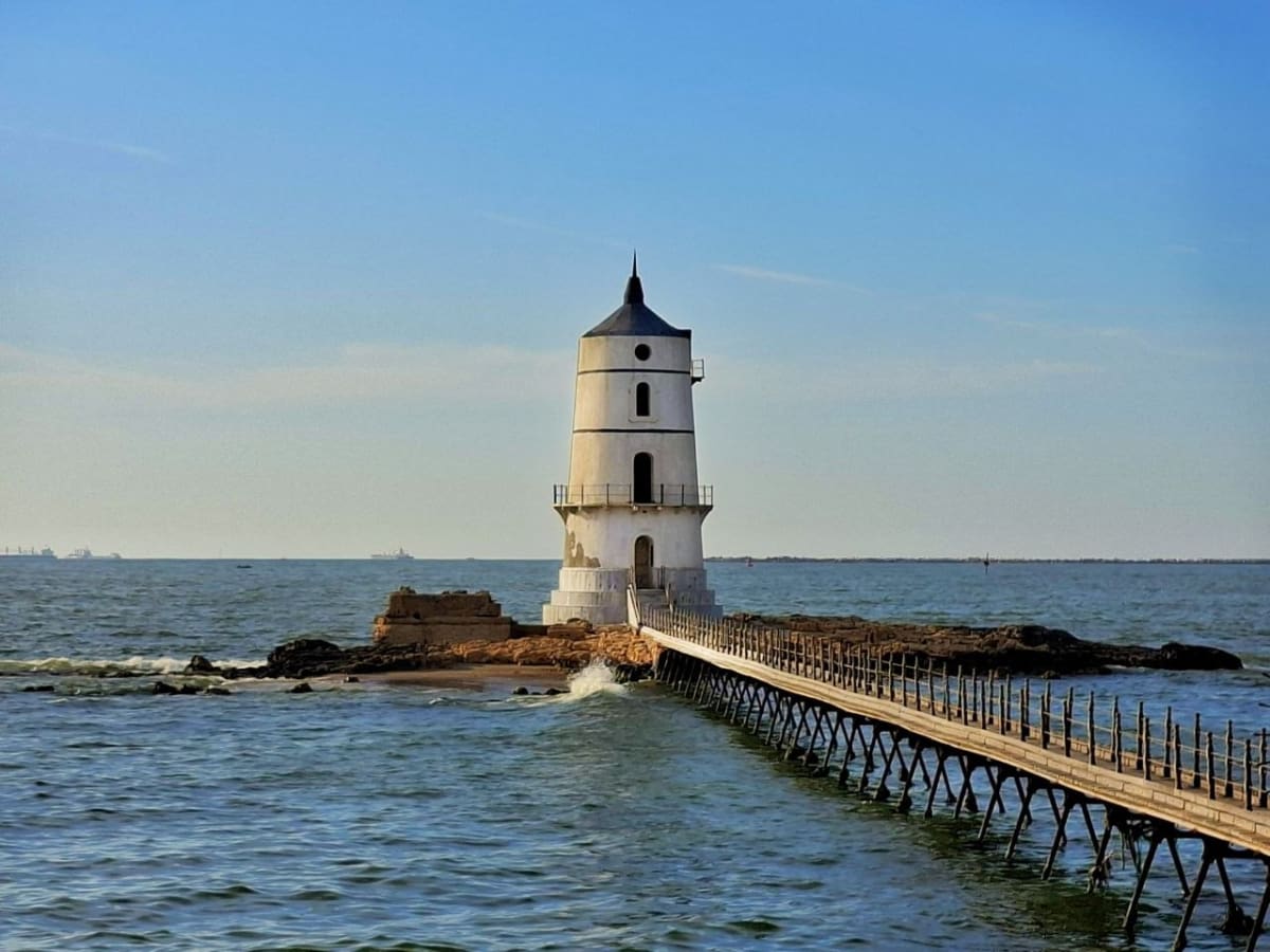
The Blind Lighthouse of El Mex

Eslam Ali

The Blind Lighthouse of El Mex

فنار المكس الأعمى: النشأة، التكوين المعماري، التشريح الوظيفي، وأسباب الأفول

يمثل فنار المكس القديم، المعروف شعبياً وتاريخياً بـ "فنار المكس الأعمى" (El Fanara El Amya / Blind Lighthouse)، حالة دراسية استثنائية وعميقة تجمع بين التراث الصناعي البحري، والتحولات التكنولوجية السريعة في هندسة الموانئ، والدراما الوجودية للآثار المهملة التي فقدت غايتها الأساسية في الحياة.

الموقع الجغرافي والنشأة التاريخية

تأسس هذا الفنار التاريخي بالتزامن وبشراكة هندسية مع فنار المكس العالي في الفترة الممتدة بين عامي 1890 و 1891، وتم افتتاحه للعمليات الملاحية الرسمية كمشروع حيوي في عام 1894، بتكلفة مالية مدمجة مع الفنار العالي قدرت بـ 3600 جنيه مصري. تم اختيار موقعه بدقة جغرافية وملاحية فائقة ليكون مبنياً على قمة جزيرة صخرية صغيرة تقبع قبالة الساحل مباشرة، إلى الغرب من حي المكس، وتبعد عن اليابسة مسافة تقدر بنحو 150 متراً. ويحدد موقعه الفلكي الدقيق من قبل هيئات المساحة البحرية عند الإحداثيات 31°09′25″ شمالاً و 29°50′51″ شرقاً. في سنوات مجده الأولى، كان الفنار متصلاً باليابسة المجاورة عبر جسر خشبي متين يسهل وصول المشغلين، وحراس الفنار، وفرق الصيانة اليومية، إلا أن هذا الجسر تحطم وانهار تماماً مع مرور الزمن بفعل العوامل الجوية القاسية والأمواج العاتية التي تضرب المنطقة في نوات الإسكندرية الشتوية المشهورة، مما جعل الوصول إلى الفنار مقتصراً حصرياً على القوارب الصغيرة في الوقت الراهن.

التكوين المعماري والخصائص الإنشائية: جدلية التوثيق والتعديلات

تتفاوت المصادر التاريخية والسجلات الهندسية في وصف الهيكل المعماري الدقيق والمورفولوجي لفنار المكس الأعمى، وهو تفاوت لا يعكس بالضرورة خطأً في التوثيق، بل يعكس على الأرجح سلسلة التعديلات الإنشائية والترميمات التي طرأت عليه خلال فترة خدمته القصيرة أو التدهور التدريجي الذي لحق به لاحقاً بعد هجرانه.

تشير مجموعة من التوثيقات والمقالات المعاصرة إلى أن الفنار عبارة عن برج خرساني ضخم سداسي الأضلاع (Hexagonal concrete tower) يبلغ ارتفاعه الكلي 11 متراً (نحو 36 قدماً)، وينتهي في أعلاه بقبة مخروطية الشكل (Conical dome) تعرضت لانهيار جزئي أو تدمير كامل في الفترات اللاحقة نتيجة الإهمال. كما تُجمع هذه المصادر على أن البرج السداسي كان مطلياً بالكامل باللون الأسود الكثيف لجعله علامة بحرية داكنة تبرز بوضوح وسط زبد البحر الأبيض، غير أن هذا الطلاء قد بهت وتقشر بشدة نتيجة الإهمال والتعرض المستمر للأملاح والبيئة البحرية القاسية.

في المقابل، تقدم سجلات معمارية أخرى (وخاصة الدراسات الأكاديمية الصادرة عن جمعيات التراث الملاحي بالإسكندرية) وصفاً هندسياً مختلفاً، حيث تميل إلى اعتبار الهيكل مكوناً بشكل أساسي من كتل الحجر الرملي الأبيض (White sandstone)، بارتفاع يقارب 14 متراً، ويتميز بوجود شرفتين للمراقبة (Two galleries) وبدون غرفة فانوس تقليدية في الأعلى، مع الإشارة المؤكدة إلى أن طلاءه الخارجي الأصلي كان يتألف من خطوط عمودية لافتة باللونين الأسود والأبيض.

يمكن للباحث المتخصص في العمارة الصناعية تفسير هذا التباين الظاهري في الوصف بأن الهيكل الحجري الأبيض المخطط يمثل المرحلة الأولى والأصلية من البناء (1890)، في حين أن التدعيم الخرساني السداسي والطلاء الأسود الكلي هما نتاج تعديل هيكلي طارئ أُجري عليه لاحقاً، ربما لتدعيمه ضد النحر البحري أو لتغيير هويته البصرية كعلامة نهارية قبل أو بعد خروجه من الخدمة الملاحية الرسمية بفترة وجيزة. ومما يعزز هذا الطرح التحليلي الإشارة التاريخية الدقيقة إلى أن الفنار، وحتى أوائل العشرينيات من القرن الماضي (أي بعد عقد كامل من إطفاء ضوئه)، كان لا يزال يستخدم رسمياً من قبل سلطات الميناء كـ "برج إشارات" (Signal Tower) نهاري، ويُشار إليه في بعض الخرائط الفرنسية والملاحية المعتمدة بـ "البرج الصغير للمكس" (petite tour de Mex).

الديناميكية الملاحية وأسباب الخروج من الخدمة (العمى الوظيفي)

خلال فترة تشغيله المضيئة التي استمرت لنحو 14 عاماً متصلة (من 1894 إلى 1908)، لعب فنار المكس الأعمى دوراً محورياً وحاسماً في تأمين دخول السفن التجارية والعسكرية العملاقة إلى منطقة البوغاز الكبير المؤدي لميناء الإسكندرية. فقد كان يعمل بانسجام تام جنباً إلى جنب مع فنار المكس العالي مشكلاً نظام أضواء دليلية (Range Lights) متطوراً، حيث كان الفنار القديم يمثل دور "الفنار الأمامي" لمسار ملاحي دقيق محدد بعناية. وعند اصطفافه بصرياً بشكل عمودي مع الفنار العالي، كان يُرشد قباطنة السفن بأمان مطلق عبر أحد الممرين الآمنين الرئيسيين المؤديين إلى الميناء التجاري.

إلا أن مسارات الملاحة البحرية، والتطورات التكنولوجية المتسارعة في هندسة بناء السفن، وفلسفة إدارة الموانئ في العصر الحديث لم تقف ساكنة. ففي مطلع القرن العشرين، ومع التحول الجذري من السفن الشراعية إلى السفن البخارية العملاقة، وازدياد الغاطس المائي لهذه السفن (Draft)، اقتضت التحديثات الهندسية في تخطيط الممرات المائية وتعميقها (Dredging) في الإسكندرية تغييراً استراتيجياً وجوهرياً في مسارات الدخول الآمنة عبر البوغاز الكبير. ونتيجة حتمية لهذه الهندسة المائية الجديدة، تم اتخاذ قرار سيادي وملاحي بتعديل زاوية خط الاقتراب الملاحي للسفن (Maritime approach line) القادمة من عرض البحر الأبيض المتوسط. لقد تقرر تغيير مسار الدخول من الزاوية السابقة البالغة 134 درجة (المتجهة نحو الجنوب الشرقي) لتصبح الزاوية الحالية والمعتمدة البالغة 113 درجة (باتجاه الشرق-جنوب شرق).

مع هذا التعديل الهندسي الدقيق والمفصلي في الزوايا الملاحية، فقد المسار القديم، الذي كان يحدده بدقة فنار المكس القديم مع الفنار العالي، وظيفته الملاحية تماماً، وأصبح الاسترشاد به يشكل خطراً لا محالة. وتنفيذاً لمعايير السلامة البحرية الصارمة، وفي اليوم الأول من شهر يناير عام 1908، تم إطفاء ضوء هذا الفنار المهيب رسمياً وبشكل نهائي. وتزامن هذا الإطفاء الدرامي مع انتهاء أعمال تشييد وافتتاح برج "فنار المكس الواطي" الجديد ليحل محله ويتولى هو دور الفنار الأمامي، متوافقاً بشكل هندسي مثالي مع زاوية الـ 113 درجة الملاحية الجديدة.

ومنذ تلك اللحظة التاريخية الفاصلة في عام 1908، أُطلق على الفنار القديم في الوجدان الشعبي والبحري لقب "فنار المكس الأعمى". يعود هذا اللقب الشعبي البليغ والمعبر إلى حقيقة مادية ومجازية تجسدت في واقعه؛ فمن الناحية المادية الصرفة، فَقَد الفنار مصدر إضاءته وروحه الوامضة، فأصبح كتلة خرسانية مظلمة (Blind) لا تبصر طريق السفن الشاردة ولا تُبصر في عتمة الليل الدامس، متقاعداً قسراً عن الخدمة بعد أن كانت نيرانه تخترق ضباب البحر العتيد وتمنح الأمل للبحارة. ومن الناحية المجازية والسوسيولوجية، يشير اللقب بمرارة إلى الإهمال والتهميش القاسي الذي طال هذا الصرح الرائد، حيث تكسرت جسوره الخشبية التي كانت تصله بالبشر، وانهارت قبته الهندسية، وتُرك وحيداً ومنبوذاً على صخرته البازلتية يواجه قسوة عوامل التعرية، رياح النوات، ورذاذ الملح دون أي محاولات جدية للترميم، أو الصيانة، أو إعادة التوظيف.


The Blind Lighthouse of El Mex: Origins, Architectural Composition, Functional Structure, and Reasons for its Decline

The old El Mex Lighthouse, popularly and historically known as the "Blind Lighthouse of El Mex" (El Fanara El Amya / Blind Lighthouse), represents an exceptional and profound case study, combining maritime industrial heritage, rapid technological transformations in port engineering, and the existential drama of neglected monuments that have lost their fundamental purpose.

Geographical Location and Historical Origins

This historic lighthouse was established concurrently and in engineering partnership with the High Lighthouse of El Mex between 1890 and 1891. It was officially opened for navigational operations as a vital project in 1894, at a combined cost of 3,600 Egyptian pounds. Its location was chosen with exceptional geographical and navigational precision, situated atop a small rocky island directly off the coast, west of the El Mex district, approximately 150 meters from the mainland. Its precise astronomical location is determined by the Hydrographic Survey at coordinates 31°09′25″N and 29°50′51″E. In its early glory, the lighthouse was connected to the mainland by a sturdy wooden causeway, facilitating access for operators, lighthouse keepers, and daily maintenance crews. However, this causeway eventually collapsed due to harsh weather conditions and the powerful waves that batter the region during Alexandria's famous winter storms, making access to the lighthouse currently limited to small boats.

Architectural Composition and Structural Characteristics: The Debate of Documentation and Modifications

Historical sources and engineering records vary in their descriptions of the precise architectural structure and morphology of the Blind Lighthouse of Mex. This variation does not necessarily reflect errors in documentation, but rather likely reflects a series of structural modifications and restorations it underwent during its short service life, or the gradual deterioration it subsequently suffered after its abandonment.

A number of contemporary documents and articles indicate that the lighthouse was a massive hexagonal concrete tower, 11 meters (approximately 36 feet) tall, topped with a conical dome that suffered partial or complete collapse in later periods due to neglect. These sources also agree that the hexagonal tower was once painted entirely in a thick black paint to serve as a dark maritime marker that would stand out clearly against the white sea foam. However, this paint has faded and peeled considerably due to neglect and constant exposure to salt and the harsh marine environment.

In contrast, other architectural records (particularly academic studies from Alexandria's Maritime Heritage Associations) offer a different architectural description. They tend to consider the structure primarily composed of white sandstone blocks, approximately 14 meters high, featuring two galleries and lacking a traditional lantern room at the top. These records also emphasize that its original exterior paint consisted of striking vertical stripes in black and white.

A scholar specializing in industrial architecture might explain this apparent discrepancy by suggesting that the white sandstone structure represents the initial, original phase of construction (1890), while the hexagonal concrete bracing and overall black paint are the result of a later, perhaps emergency, structural modification. This modification may have been implemented to protect the structure against marine erosion or to alter its visual identity as a daytime marker shortly before or after its decommissioning. Further supporting this analytical approach is the accurate historical record that the lighthouse, even until the early 1920s (a full decade after its lights were extinguished), was still officially used by the port authorities as a daytime signal tower, and is referred to in some French and nautical charts as the "petite tour de Mex" (little tower of Mex).

Navigational Dynamics and Reasons for Decommissioning (Functional Blindness)

During its illuminating period of approximately 14 consecutive years (from 1894 to 1908), the blind Mex lighthouse played a pivotal and crucial role in ensuring the safe passage of giant merchant and military vessels into the Grand Canal leading to the port of Alexandria. It operated in perfect harmony with the tall Mex lighthouse, forming a sophisticated range light system, with the old lighthouse serving as the "foreground beacon" for a carefully defined navigational route. When aligned visually perpendicular to the tall lighthouse, it guided ship captains with absolute safety through one of the two main safe passages leading to the commercial harbor.

However, maritime navigation routes, rapid technological advancements in shipbuilding, and modern port management philosophies did not remain static. At the beginning of the 20th century, with the radical shift from sailing ships to giant steamships and the increased draft of these vessels, engineering updates in the planning and dredging of Alexandria's waterways necessitated a fundamental strategic change in the safe entry routes through the Great Strait. As an inevitable consequence of this new water engineering, a sovereign and navigational decision was made to modify the angle of the maritime approach line for ships coming from the open Mediterranean. It was decided to change the entry angle from the previous 134 degrees (southeastward) to the current and approved angle of 113 degrees (east-southeastward).

With this precise and crucial engineering modification to the navigational angles, the old course, which had been accurately determined by the old lighthouse of Mex in conjunction with the high lighthouse, completely lost its navigational function, and using it became undeniably dangerous. In compliance with strict maritime safety standards, on the first day of January 1908, the light of this lighthouse was extinguished.