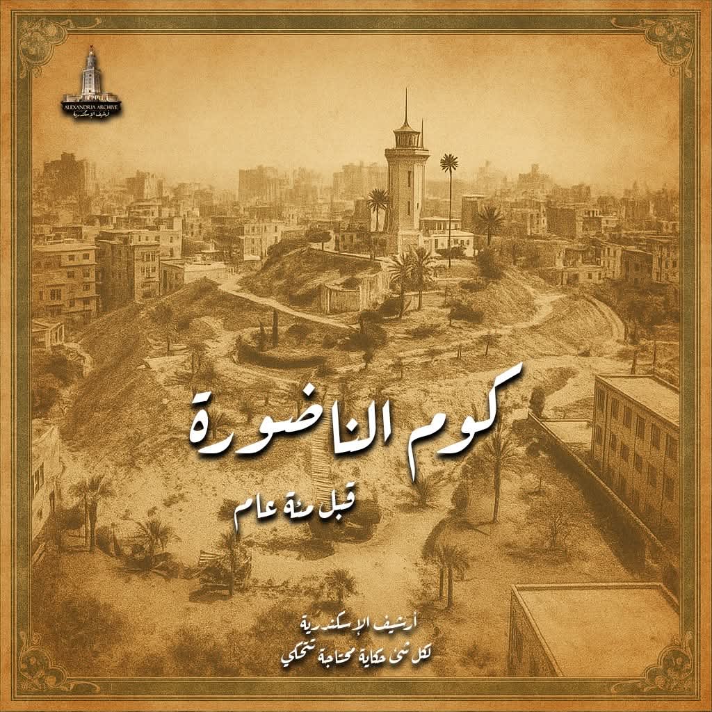
كوم الناضورة قبل مئة عام: حين كانت الإسكندرية القديمة تنبض بالحياة حول التل الأثري
وسط أزقة حي الأنفوشي بالإسكندرية، يقف اليوم تل «كوم الناضورة» شامخًا، يحمل بين طبقاته تاريخًا طويلًا من التحولات التي شهدتها المدينة على مرّ القرون. لكن لو عدنا بالزمن قرنًا إلى الوراء، إلى عشرينيات القرن العشرين، لكانت الصورة مختلفة تمامًا — خريطة المدينة حول التل كانت تموج بالحياة، تعكس تداخل العصور القديمة والحديثة في مشهد واحد ساحر.
ملامح الخريطة في بدايات القرن العشرين
في تلك الفترة، كانت الإسكندرية قد تجاوزت مرحلة الأسوار القديمة وأصبحت مدينة مزدوجة الشخصية: جزء شرقي حديث يعبّر عن الطابع الأوروبي، وجزء غربي عريق يحتفظ بالروح المصرية والعثمانية.
وكان «كوم الناضورة» يقع في قلب هذا العالم القديم، محاطًا بشبكة من الأزقة الضيقة غير المنتظمة، تمتد منها طرق رئيسية نحو الجمارك والأنفوشي واللبان.
كانت المنطقة ما تزال تحمل آثار الحصن الذي أنشأه الفرنسيون خلال حملتهم على مصر (1798–1801)، والمعروف باسم حصن كافاريلي، الذي استُخدم لاحقًا كموقع دفاعي ثم كمخزن وخزانات مياه تحت الأرض. ومع مرور العقود، تحوّل التل من موقع عسكري إلى منطقة مأهولة تحيط بها بيوت صغيرة وورش حرفية.
الإسكندرية كما كانت تُرى من أعلى التل
من على قمة كوم الناضورة، كان يمكن للمرء أن يرى مزيجًا مذهلًا من العصور:
في الأفق الغربي تمتد أحياء «اللبان» و«الجمرك» بعمارتها المتراصة وشوارعها المتعرجة، بينما من الشرق يمكن تمييز الميناء القديم الذي ظل لقرون شريان الحياة الاقتصادية للمدينة.
البيوت كانت تتكون من طابقين أو ثلاثة، بواجهات من الحجر والطوب، تعلوها شرفات خشبية وزخارف بسيطة. أما الشوارع، فكانت تضيق وتتسع على غير نظام، تحفّ بها مساجد صغيرة وزوايا صوفية وأسواق محلية نابضة بالحركة.
في المساء، كان ضوء الفوانيس الزيتية ينعكس على جدران البيوت القديمة، بينما يعلو صوت المؤذنين من مآذن قصيرة الطول تملأ الحي بروح دافئة تعبق بتاريخ طويل من التدين الشعبي والحياة اليومية البسيطة.
الطابع العمراني والاجتماعي للمنطقة
تجمع منطقة كوم الناضورة في ذلك الوقت بين التأثيرات العثمانية والمصرية والأوروبية المبكرة.
فالمنازل كانت تحمل ملامح العمارة الإسلامية في تقسيمها الداخلي، لكنها تأثرت بالتخطيط الأوروبي الذي بدأ يظهر في شوارع الإسكندرية بعد التوسع العمراني في عهد محمد علي باشا وأبنائه.
لم تكن المنطقة فقط موطنًا للسكان البسطاء والحرفيين، بل كانت أيضًا شاهدة على طبقات من التاريخ؛
ففي باطن التل ترقد آثار تعود إلى عصور البطالمة والرومان، بينما على سطحه تروي الأزقة والبيوت قصص الإسكندرية الحديثة وهي تشق طريقها نحو الحداثة.
خريطة متخيلة للإسكندرية القديمة
لو رسمنا خريطة تخيلية للمنطقة قبل مئة عام، لوجدنا أن:
التل الأثري يحتل المركز، محاطًا بحزام من الأزقة المتداخلة والمنازل القديمة.
من الغرب تمتد الطرق نحو الجمارك والورديان، حيث النشاط التجاري والمخازن.
من الشرق تبرز ملامح المدينة الحديثة في طريقها نحو المنشية والميناء.
المساجد والزوايا تنتشر بكثرة حول التل، مثل مسجد علي بك ومسجد الفحام ومسجد الطرابي.
الحياة اليومية كانت نابضة في الأسواق الصغيرة والحارات، حيث تتجاور الورش مع المقاهي والمحال البسيطة.
مشهد من الماضي
تخيل المشهد:
أزقة ضيقة مرصوفة بالحجر، أطفال يركضون بين الحارات، أصوات الباعة تملأ المكان، ورائحة الخبز الطازج تتسلل من الأفران الطينية. من بعيد، يظهر «كوم الناضورة» كتلة مرتفعة يعلوها صمت التاريخ، تحرس المدينة التي لا تنام.
كان المكان أكثر من مجرد تل أثري، بل ذاكرة حية تجمع بين الإسكندرية القديمة والإسكندرية الحديثة، بين البحر والتاريخ، بين الإنسان والحجر.
قبل مئة عام، لم يكن «كوم الناضورة» مجرد موقع أثري مهمل كما يبدو اليوم، بل كان قلبًا نابضًا في جسد المدينة القديمة.
تحيط به الحياة من كل جانب، تتداخل فيه الأزمنة والأنفاس، وتنبعث منه رائحة الإسكندرية الحقيقية — مدينة البحر والذاكرة، التي لم تفقد يومًا سحرها مهما تبدلت الوجوه والخرائط.
#أرشيف_الاسكندرية
#alexandria_archive
Kom Al-Nadora
Kom El-Nadoura a Century Ago: When Ancient Alexandria Thrived Around the Archaeological Mound
Amidst the alleyways of Alexandria's Anfoushi district, Kom El-Nadoura mound stands proudly, its layers bearing witness to the city's long history of transformations over the centuries. But if we were to travel back a century, to the 1920s, the picture would be entirely different—the city map around the mound teemed with life, reflecting the interplay of ancient and modern eras in a single, captivating scene.
The Map's Features in the Early 20th Century
By that time, Alexandria had transcended its old walls and become a city of dual character: a modern eastern part reflecting a European character, and a traditional western part preserving its Egyptian and Ottoman spirit.
Kom El-Nadoura lay at the heart of this ancient world, surrounded by a network of narrow, irregular alleyways from which main roads radiated towards El-Gomrok, Anfoushi, and El-Labban.
The area still bore the marks of the fort built by the French during their campaign in Egypt (1798–1801), known as Fort Caffarelli, which was later used as a defensive position and then as an underground storage facility and water reservoir. Over the decades, the hill transformed from a military site into a populated area surrounded by small houses and workshops.
Alexandria as seen from the top of the hill
From the summit of Kom El-Nadoura, one could witness a stunning blend of eras:
To the west, the neighborhoods of El-Labban and El-Gomrok stretched out with their tightly packed architecture and winding streets, while to the east, the ancient port, which for centuries had been the economic lifeblood of the city, was clearly visible.
The houses were two or three stories high, with stone and brick facades topped by wooden balconies and simple decorations. The streets, with their irregular narrowing and widening, were lined with small mosques, Sufi lodges, and bustling local markets.
In the evening, the light of oil lamps reflected off the walls of the old houses, while the call to prayer from the low minarets filled the neighborhood with a warm atmosphere steeped in a long history of popular piety and simple daily life.
The Architectural and Social Character of the Area
The Kom El-Nadoura area at that time combined Ottoman, Egyptian, and early European influences.
The houses bore the hallmarks of Islamic architecture in their internal layouts, but they were also influenced by the European urban planning that began to appear in the streets of Alexandria after the urban expansion during the reign of Muhammad Ali Pasha and his sons.
The area was not only home to ordinary people and craftsmen, but it also bore witness to layers of history.
Beneath the hill lay ruins dating back to the Ptolemaic and Roman eras, while on its surface, the alleyways and houses told the stories of modern Alexandria as it forged its path toward modernity.
An Imagined Map of Ancient Alexandria
If we were to draw an imagined map of the area a hundred years ago, we would find that:
The archaeological mound occupies the center, surrounded by a ring of interconnected alleyways and old houses.
From the west, roads extend towards the Customs and Wardian districts, where commercial activity and warehouses were concentrated.
From the east, the features of the modern city emerge on its way towards Mansheya and the port.
Mosques and zawiyas (Sufi lodges) are scattered around the mound, such as the Ali Bey Mosque, the Al-Fahham Mosque, and the Al-Tarabi Mosque.
Daily life throbbed in the small markets and alleyways, where workshops stood alongside cafes and simple shops.
A Scene from the Past
Imagine the scene:
Narrow, stone-paved alleyways; children running between them; the voices of vendors filling the air; and the aroma of freshly baked bread wafting from clay ovens. In the distance, Kom El-Nadoura appears, a high mass imbued with the silence of history, guarding the city that never sleeps.
The place was more than just an archaeological mound; it was a living memory, a bridge between ancient and modern Alexandria, between the sea and history, between people and stone.
A hundred years ago, Kom El-Nadoura was not merely a neglected archaeological site as it appears today, but a vibrant heart within the ancient city.
Life surrounded it on all sides, a fusion of time and breath, emanating the very essence of Alexandria—a city of the sea and memory, which has never lost its magic, no matter how faces and maps have changed.