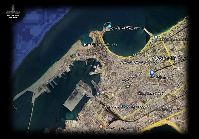
مدينة الإسكندرية ما بين عام ٣٠ قبل الميلاد و بين عام ٢٠٢٣ بأحدث صور جوية للمدينة
ما يمكن ملاحظته في الصورتين هو عدم وجود بعض مناطق المدينة مثل منطقة "المنشية" بالكامل و نلاحظ وجود الهيبتاستاديون و هو جسر بُني للربط بين الساحل الاساسي للمدينة و بين جزيرة فاروس و كان هذا الجسر يساوي في طوله ٧ اضعاف الاستاد اليوناني في ذلك الوقت و لذلك تمت تسميته بهذا الأسم.
ايضًا في الصورة نلحظ وجود الميناء الشرقي و الميناء الغربي للمدينة والميناء الشرقي أحد أقدم الموانئ في العالم حيث تم بناء أولى إنشاءاته عام 2000 ق.م. في قرية راقودة القديمة لخدمة المناطق الساحلية في جزيرة فاروس (الآن منطقة رأس التين بالمدينة). ويحده من الغرب خليج الأنفوشي. مياه الميناء الشرقي ضحلة وترسو به قوارب صيد ويخوت والآخر هو الميناء الغربي وهو ما يعرف بـ"ميناء الإسكندرية البحري"
مع مرور السنين و تراكم طمي نهر النيل في المنطقة الفاصلة بين جزيرة فاروس و قرية راقودة و مع وقوع زلزال الإسكندرية المدوي الذي ادى الى انهيار منارة الإسكندرية و احد عجائب الدنيا السبع القديمة اندثر الهيبتاستاديون تحت عدة امتار من الطمي و التربة ما شكل فيما بعد على مر العصور منطقة "المنشية" و هو ما بنى عليه العثمانيون مدينتهم في عام ١٥١٧م صاعداً.
#ارشيف_الإسكندرية
An old map of Alexandria
Alexandria between 30 BC and 2023 in the latest aerial photographs.
What is noticeable in the two images is the complete absence of certain areas of the city, such as the Mansheya district. We can see the Heptastadion, a causeway built to connect the city's mainland to Pharos Island. This causeway was seven times the length of the Greek stadium of its time, hence its name.
Also visible in the images are the city's eastern and western harbors. The eastern harbor is one of the oldest in the world, with its first construction dating back to 2000 BC in the ancient village of Rhakotis, serving the coastal areas of Pharos Island (now the Ras El Tin district of Alexandria). It is bordered to the west by Anfoushi Bay. The waters of the eastern harbor are shallow and moored by fishing boats and yachts, while the western harbor is known as the "Alexandria Seaport."
Over the years, the Nile River silt accumulated in the area between Pharos Island and the village of Rhakotis. Following the devastating Alexandria earthquake, which led to the collapse of the Lighthouse of Alexandria, one of the Seven Wonders of the Ancient World, the Heptastadion was buried under several meters of silt and soil. This silt later formed the area of "Mansheya," upon which the Ottomans built their city starting in 1517 AD.